
“ScaMook” National Park Concept
ScaMook National Park is a conceptual new linear national park combining two existing recreational trails (CZ and Banks-Vernonia) with the evolving Salmonberry Trail. It would connect urban Portland by way of Scappoose to rural Tillamook, Oregon on the Pacific Coast Highway. This linear park would weave through historic Native American lands and magnificent forests located in the coastal mountains of NW Oregon, passing through numerous picturesque small towns and communities.

Native American Heritage

Area Communities & Roads

The Nehalem River
The Nehalem River is an Oregon Coast gem that includes critical habitat for some of the best wild salmon and steelhead runs left in the Lower 48. It has long attracted Oregonians to hike, fish, camp, and float its clear waters. It’s also the North Coast’s longest river, aside from the mighty Columbia, and the Nehalem watershed includes important tributaries like the crystal clear Salmonberry River.
The Scenic Waterways program was passed by ballot measure in response to dam construction, suction dredge mining, and increasing development pressures on Oregon’s iconic rivers. It allows the state to reserve our natural waterways for their scenic, habitat and recreation values. After several rivers were initially designated, the program became largely dormant until 2016. Currently, only 22 river segments are designated as State Scenic Waterways in Oregon, which equates to less than 1% of the state’s rivers and streams.
The Nehalem is a perfect candidate for the designation, with old native forests, stunning trails, scenic waterfalls, and fish and wildlife habitat. The Nehalem is the largest “wild fish only” river on the Oregon Coast and is home to an unusually rich diversity of salmonids: three races of Chinook, some of the last chum on the coast, cutthroat trout, coho, and a race of extra large winter-run steelhead. Older forests along this stretch are also important habitat for endangered marbled murrelets, which nest on the limbs of big, old trees.

ScaMook Area Communities @ Wikepedia
Scappoose & ST Helens
Scappoose /skæˈpuːs/ is a city in Columbia County, Oregon, United States. The population is 8,010 according to the 2020 Census nestled in the scenic northwest part of the state. Its history is rich and intertwined with the indigenous people, the European settlers, and the natural resources that define the Pacific Northwest.
Before European settlement, the area was inhabited by the Chinookan-speaking Native American tribes, who lived along the Columbia River and its tributaries. These tribes were known for their fishing, canoeing, and trading skills, with a culture deeply connected to the river and the abundant natural resources of the region.
The name “Scappoose” is derived from a Native American word, believed to mean “gravelly plain,” reflecting the area’s physical characteristics. European exploration and settlement in the Oregon territory began in earnest in the early 19th century, with the Lewis and Clark Expedition in 1805–1806 marking one of the earliest recorded European presences in the area.
By the mid-19th century, settlers began to arrive in the region, drawn by the promise of land and resources. The Donation Land Claim Act of 1850 further encouraged settlement by offering land to settlers, leading to the establishment of homesteads, farms, and communities. Scappoose was officially incorporated as a city in 1921, marking its transition from a settlement and farming community to a recognized municipality.
Throughout the 20th century, Scappoose grew modestly, benefiting from its proximity to Portland, Oregon’s largest city, while maintaining its small-town character. The local economy historically relied on logging, agriculture, and later, light industry and services. The presence of the Scappoose Industrial Airpark, established in the mid-20th century, reflects the city’s attempts to diversify its economic base.
Today, Scappoose is known for its community-oriented lifestyle, scenic beauty, and recreational opportunities, including fishing, hiking, and exploring the Columbia River and nearby natural areas. While it has embraced modernity and growth, Scappoose retains a strong sense of its historical roots and the natural environment that has shaped its development.

A representative image of Scappoose, Oregon, capturing the essence of this peaceful and scenic community in the Pacific Northwest. * ChatGPT4 2024
St Helens
St. Helens was established as a river port on the Columbia River in the 1840s. The original town was surveyed and platted by Scottish-born Peter Crawford.[6] In 1853, the Pacific Mail Steamship Company tried to make the city their only stop on the Columbia River.[7] Portland’s merchants boycotted this effort, and the San Francisco steamship Peytona helped break the impasse.[7] St. Helens was incorporated as a city in 1889.[8]
The Lewis and Clark Expedition passed through and camped in the area that is now St. Helens on the night of November 5, 1805, while on their way to the Pacific Ocean. While there, the party encountered Native Americans and Clark observed “low rockey clifts”.[9]

Vernonia
The community was first settled in 1874 by the Parker and Van Blaricom families. Cousins Judson Weed and Ozias Cherrington, both of Ohio, arrived in 1876. Sometime afterwards, the question of a name for the community came up, and Cherrington suggested the name of his daughter (Vernona) in Ohio, which was adopted. Due to a clerical error during the incorporation process, an “i” was inserted into the name. Cherrington died in a farming accident in 1894, never having seen his daughter since his departure from Ohio.[6]
Vernonia started to become more than an isolated farming community on July 10, 1924, when the Oregon-American Lumber Company opened a state-of-the-art lumber mill, which was supported by a railroad line connecting Vernonia to the rest of the country. Oregon-American merged with Long-Bell Lumber Company in May 1953, which itself merged with International Paper in November 1957. International Paper judged the mill antiquated, and closed it on December 20, 1957.
The city has been severely impacted by floods on multiple occasions. The rains that caused the Willamette Valley Flood of 1996 flooded Vernonia as well; some homes in the floodplain were elevated, and some flooring materials were replaced, mitigating some damage from later flooding.[7] In 2007, heavy storms that impacted the Pacific Northwest washed out roads and destroyed homes, cars,[7] and communications infrastructure.[8] Despite preparations in 1996, in some parts of town flood water reached 4 feet (1.2 m) above the 100 year base flood elevation.[9] In the wake of the 2007 flood, Vernonia School District voters approved a $13 million bond in 2009 to build a new K-12 school in Vernonia.[10][11] The new school opened in fall 2012.[12]

Buxton
The Buxton area was settled by Henry T. Buxton in 1884, and the town was named for his family, including his father, also named Henry Buxton, a pioneer of 1841.[1] A post office was established on December 27, 1886, with Henry T. Buxton as the first postmaster.[1] Buxton was also the name of a station on the Portland, Astoria & Pacific Railroad above Mendenhall Creek east of the community.[1] A new school building was completed about 1938.[2] In 1954, the community joined with neighboring Manning and Banks to form the Tri-City Rural Fire Protection District (now Banks Fire District).[3] The post office continued until at least 1976 and had a zip code of 97109.[4] The Buxton School, part of the Banks School District, closed in 1998[2] with the building sold in 2000 to the Banks Christian Academy.[5] Banks Christian Academy closed the Buxton school in June 2015, with the school then being taken over by Faith Bible Christian School.[5]

Banks
Banks is a city in Washington County, Oregon, United States which is located in the Tualatin Valley. It is the southern anchor to the Banks–Vernonia State Trail, which is a 21-mile (34 km) long linear trail popular with bicyclists, hikers, and equestrians. The population was 1,777 at the 2010 census.[4] The community was named for John and Nancy Banks, who owned a nearby dairy farm.[5] Incorporated in 1921, it is located in the western part of the county where Oregon Route 6 intersects Oregon Route 47.

Timber
Timber was the site of multiple logging operations back in the early days of timber harvesting in Oregon. A railroad was built through the town[4] and served as an important method of transportation for both lumber and passengers between Tillamook, the Willamette Valley, and Portland. There have been multiples large fires near the area including the Tillamook and Salmonberry burns. With the introduction of highways, panning out of the large stocks of old-growth lumber, and the decommissioning of the railroad, the town population declined from its former heydays.

Clatskanie
The town was originally called Bryantville after the large family who were among the first filers of Donation Land Claims in the area in 1852-53. However, the first postmaster, Enoch Conyers, who was married to one of the Bryant daughters, changed the name to Clatskanie after the Tlatskanai Native American tribe.[citation needed]
According to the Clatsop County pioneer Silas B. Smith, Tlatskanai was a point in the Nehalem River that was reached from the Columbia River by way of the Youngs River or by way of the Clatskanie River. The native inhabitants, who were not in the habit of naming streams, did not use the word Tlatskanai for the streams they would follow in order to get to that point, but the white men who settled here later did apply the name to the streams.[5]
Many of Clatskanie’s inhabitants are of Nordic heritage, specifically Finnish, Swedish, and Norwegian.[6]

Hillsboro
The European-American community was founded by David Hill, Isaiah Kelsey, and Richard Williams, who arrived in the Tualatin Valley in 1841, followed by six more pioneers in 1842.[8] The locality went by two other names—East Tualatin Plains and Columbia—before it was named “Hillsborough” in February 1850 in honor of Hill, when he sold part of his land claim to the county.[9] On February 5, 1850, commissioners chosen by the territorial legislature selected the community to be the seat of the county government.[9] Hill was to be paid $200 for his land after plots had been sold for the town site,[9] but he died before this occurred, and his widow Lucinda received the funds.[10] The town’s name was later simplified to Hillsboro. A log cabin was built in 1853 to serve as the community’s first school, which opened in October 1854.[11] Riverboats provided transportation to Hillsboro as early as 1867 when the side-wheel steamer Yamhill worked on the Tualatin River.[8]

Octagonal barn at Imbrie Farm
In 1871, the Oregon and California Railroad line was extended to the area, but it ran just south of town because the city did not want to give the railroad land in exchange for the rail connection.[8] Hillsboro was incorporated as the Town of Hillsboro on October 19, 1876, by the Oregon Legislature.[12] The first mayor was A. Luelling, who took office on December 8, 1876, and served a one-year term.[13] Notable later mayors included Congressman Thomas H. Tongue (1882 and 1886) and state senator William D. Hare (1885).[13] In 1923, the city altered its charter and adopted a council-manager government with a six-person city council, a part-time mayor who determined major policies, and a city manager who ran day-to-day operations.[14]
On September 30, 1908, 5,000 people gathered as the Oregon Electric Railway opened a connection between the city and Portland with an interurban electric rail line, the first to reach the community.[15] In January 1914, the Southern Pacific Railroad introduced its own interurban service, known as the Red Electric, on a separate line and serving different communities between Hillsboro and Portland.[16][17] SP discontinued its Hillsboro service on July 28, 1929,[17] while the Oregon Electric Railway’s passenger service to Hillsboro lasted until July 1932.[16]
A brick building was constructed in 1852 to house the county government, followed by a brick courthouse in 1873.[18] In 1891, the courthouse was remodeled and a clock tower was added,[19] and the building was expanded with an annex in 1912. A new courthouse replaced the brick structure in 1928. The last major remodel of the 1928 structure occurred in 1972, when the Justice Services Building was built and incorporated into the existing building.[18]
The city’s first fire department was a hook and ladder company organized in 1880 by the board of trustees (now city council).[20] A drinking water and electricity distribution system added in 1892–93 gave the town three fire hydrants and minimal street lighting.[21] Hillsboro built its first sewer system in 1911, but sewage treatment was not added until 1936.[22] In 1913, the city built its own water system,[23] and the first library, Carnegie City Library, opened in December 1914.[24] From 1921 to 1952, the world’s second-tallest radio tower stood on the south side of the city,[25] but in 1952, the wireless telegraph tower was demolished. During the 1950s and 1960s, the privately owned company Tualatin Valley Buses, Inc., provided transit service connecting Hillsboro with Beaverton and Portland.[26] It was taken over by the publicly owned transit agency TriMet in 1970.[27][28]
In 1972, the Hillsboro City Council passed a Green River Ordinance banning door-to-door solicitation, but it was ruled unconstitutional by the Oregon Supreme Court in a 1988 decision.[29] The court determined that the city ordinance was overly broad, in a case that was seen as a test case for many similar laws in the state.[29] In 1979, Intel opened its first facility in Hillsboro.[30] The Hawthorn Farm campus was followed by the Jones Farm campus adjacent to the airport in 1982, and finally by the Ronler Acres campus in 1994.[30] TriMet opened a Metropolitan Area Express (MAX) light rail line into the city in 1998. A cultural center was added in 2004, and a new city hall was completed in 2005. In 2008, SolarWorld opened a facility producing solar wafers, crystals, and cells, the largest plant of its kind in the Western Hemisphere.[31] U.S. President Barack Obama visited the city and Intel’s Ronler Acres campus in February 2011.[32]
Astoria
During archeological excavations in Astoria and Fort Clatsop in 2012, trading items from American settlers with Native Americans were found, including Austrian glass beads and falconry bells. The present area of Astoria belonged to a large, prehistoric Native American trade system of the Columbia Plateau.[8][9]

An image of Astoria in 1868 with various mast sailing ships
The Lewis and Clark Expedition spent the winter of 1805–1806 at Fort Clatsop, a small log structure southwest of modern-day Astoria. The expedition had hoped a ship would come by that could take them back east, but instead, they endured a torturous winter of rain and cold. They later returned overland and by internal rivers, the way they had traveled west.[10] Today, the fort has been recreated and is part of Lewis and Clark National Historical Park.[11]
In 1811, British explorer David Thompson, the first person known to have navigated the entire length of the Columbia River, reached the partially constructed Fort Astoria near the mouth of the river. He arrived two months after the Pacific Fur Company‘s ship, the Tonquin.[12] The fort constructed by the Tonquin party established Astoria as a U.S., rather than a British, settlement[12] and became a vital post for American exploration of the continent. It was later used as an American claim in the Oregon boundary dispute with European nations.
The Pacific Fur Company, a subsidiary of John Jacob Astor’s American Fur Company, was created to begin fur trading in the Oregon Country.[13] During the War of 1812, in 1813, the company’s officers sold its assets to their Canadian rivals, the North West Company, which renamed the site Fort George. The fur trade remained under British control until U.S. pioneers following the Oregon Trail began filtering into the town in the mid-1840s. The Treaty of 1818 established joint U.S. – British occupancy of the Oregon Country.[14][15]
Washington Irving, a prominent American writer with a European reputation, was approached by John Jacob Astor to mythologize the three-year reign of his Pacific Fur Company. Astoria (1835), written while Irving was Astor’s guest, promoted the importance of the region in the American psyche.[16] In Irving’s words, the fur traders were “Sinbads of the wilderness”, and their venture was a staging point for the spread of American economic power into both the continental interior and outward in Pacific trade.[17]
In 1846, the Oregon Treaty divided the mainland at the 49th parallel north, making Astoria officially part of the United States.[18] As the Oregon Territory grew and became increasingly more colonized by Americans, Astoria likewise grew as a port city near the mouth of the great river that provided the easiest access to the interior. The first U.S. post office west of the Rocky Mountains was established in Astoria in 1847[19] and official state incorporation in 1876.[1]
Astoria attracted a host of immigrants beginning in the late 19th century: Nordic settlers, primarily Swedes, Swedish speaking Finns, and Chinese soon became larger parts of the population. The Nordic settlers mostly lived in Uniontown, near the present-day end of the Astoria–Megler Bridge, and took fishing jobs; the Chinese tended to do cannery work, and usually lived either downtown or in bunkhouses near the canneries. By the late 1800s, 22% of Astoria’s population was Chinese.[20][21][22] Astoria also had a significant population of Indians, especially Sikhs from Punjab; the Ghadar Party, a political movement among Indians on the West Coast of the U.S. and Canada to overthrow British rule in India, was officially founded on July 15, 1913, in Astoria.[23]
In 1883, and again in 1922, downtown Astoria was devastated by fire, partly because the buildings were constructed mostly of wood, a readily available material. The buildings were entirely raised off the marshy ground on wooden pilings. Even after the first fire, the same building format was used. In the second fire, flames spread quickly again, and the collapsing streets took out the water system. Frantic citizens resorted to dynamite, blowing up entire buildings to create fire stops.[24][25]
Astoria has served as a port of entry for over a century and remains the trading center for the lower Columbia basin. In the early 1900s, the Callendar Navigation Company was an important transportation and maritime concern based in the city.[26] It has long since been eclipsed in importance by Portland, Oregon, and Seattle, Washington, as economic hubs on the coast of the Pacific Northwest. Astoria’s economy centered on fishing, fish processing, and lumber. In 1945, about 30 canneries could be found along the Columbia River.
In the early 20th century, the North Pacific Brewing Company contributed substantially to the economic well-being of the town.[27] Before 1902, the company was owned by John Kopp, who sold the firm to a group of five men, one of whom was Charles Robinson, who became the company’s president in 1907.[28][29] The main plant for the brewery was located on East Exchange Street.[30]
As the Pacific salmon resource diminished, canneries were closed. In 1974, the Bumble Bee Seafoods corporation moved its headquarters out of Astoria and gradually reduced its presence until closing its last Astoria cannery in 1980.[31] The lumber industry likewise declined in the late 20th century. Astoria Plywood Mill, the city’s largest employer, closed in 1989. The Burlington Northern and Santa Fe Railway discontinued service to Astoria in 1996, as it did not provide a large enough market.[32]
From 1921 to 1966, a ferry route across the Columbia River connected Astoria with Pacific County, Washington. In 1966, the Astoria–Megler Bridge was opened. The bridge completed U.S. Route 101 and linked Astoria with Washington on the opposite shore of the Columbia, replacing the ferry service.[33]
Today, tourism, Astoria’s growing art scene, and light manufacturing are the main economic activities of the city. Logging and fishing persist, but at a fraction of their former levels.[34] Since 1982 it has been a port of call for cruise ships, after the city and port authority spent $10 million in pier improvements to accommodate these larger ships.
To avoid Mexican ports of call during the swine flu outbreak of 2009, many cruises were rerouted to include Astoria. The floating residential community MS The World visited Astoria in June 2009.[35]
The town’s seasonal sport fishing tourism has been active for several decades.[36][37][38] Visitors attracted by heritage tourism and the historic elements of the city have supplanted fishing in the economy. Since the early 21st century, the microbrewery/brewpub scene[39] and a weekly street market[40] have helped popularize the area as a destination.

The Astoria Column
In addition to the replicated Fort Clatsop, another point of interest is the Astoria Column, a tower 125 feet (38 m) high, built atop Coxcomb Hill above the town. Its inner circular staircase allows visitors to climb to see a panoramic view of the town, the surrounding lands, and the Columbia flowing into the Pacific. The tower was built in 1926. Financing was provided by the Great Northern Railway, seeking to encourage tourists, and Vincent Astor, a great-grandson of John Jacob Astor, in commemoration of the city’s role in the family’s business history and the region’s early history.[41][42]
Since 1998, artistically inclined fishermen and women from Alaska and the Pacific Northwest have traveled to Astoria for the Fisher Poets Gathering, where poets and singers tell their tales to honor the fishing industry and lifestyle.[43]
Another popular annual event is the Dark Arts Festival, which features music, art, dance, and demonstrations of craft such as blacksmithing and glassblowing, in combination with offerings of a large array of dark craft brews. Dark Arts Festival began as a small gathering at a community arts space. Now Fort George Brewery hosts the event, which draws hundreds of visitors and tour buses from Seattle.[44]
Astoria is the western terminus of the TransAmerica Bicycle Trail, a 4,250-mile (6,840 km) coast-to-coast bicycle touring route created in 1976 by the Adventure Cycling Association.[45]
Three United States Coast Guard cutters: the Steadfast, Alert, and Elm, are homeported in Astoria.[46]
Portland
The history of the city of Portland, Oregon, began in 1843 when business partners William Overton and Asa Lovejoy filed to claim land on the west bank of the Willamette River in Oregon Country. In 1845 the name of Portland was chosen for this community by coin toss. February 8, 1851, the city was incorporated.[1] Portland has continued to grow in size and population, with the 2020 Census showing 652,503 residents in the city.[2]
The land today occupied by Multnomah County, Oregon, was inhabited for centuries by two bands of Upper Chinook Indians. The Multnomah people settled on and around Sauvie Island and the Cascades Indians settled along the Columbia Gorge. These groups fished and traded along the river and gathered berries, wapato and other root vegetables. The nearby Tualatin Plains provided prime hunting grounds.[3] Eventually, contact with Europeans resulted in the decimation of native tribes by smallpox and malaria.[4]

Portland in 1853
The site of the future city of Portland, Oregon, was known to American, Canadian, and British traders, trappers and settlers of the 1830s and early 1840s as “The Clearing,”[5] a small stopping place along the west bank of the Willamette River used by travelers en route between Oregon City and Fort Vancouver. As early as 1840, Massachusetts sea captain John Couch logged an encouraging assessment of the river’s depth adjacent to The Clearing, noting its promise of accommodating large ocean-going vessels, which could not ordinarily travel up-river as far as Oregon City, the largest Oregon settlement at the time. In 1843, Tennessee pioneer William Overton and Boston, Massachusetts lawyer Asa Lovejoy filed a 640 acres (260 ha) land claim with Oregon’s provisional government that encompassed The Clearing and nearby waterfront and timber land. Legend has it that Overton had prior rights to the land but lacked funds, so he agreed to split the claim with Lovejoy, who paid the 25-cent filing fee.[6]


Asa Lovejoy Francis Pettygrove
Attorney Asa Lovejoy and merchant Francis Pettygrove are considered the city’s founders.
Lovejoy and Pettygrove built Portland’s first house, a log cabin near the present intersection of Washington Street and Naito Parkway, in 1844.[7][8]
Bored with clearing trees and building roads, Overton sold his half of the claim to Francis W. Pettygrove of Portland, Maine, in 1845.[citation needed] When it came time to name their new town, Pettygrove and Lovejoy both had the same idea: to name it after his home town. They flipped a coin to decide, and Pettygrove won. On November 1, 1846, Lovejoy sold his half of the land claim to Benjamin Stark, as well as his half-interest in a herd of cattle for $1,215.[9]
Three years later, Pettygrove had lost interest in Portland and become enamored with the California Gold Rush. On September 22, 1848, he sold the entire townsite, save only for 64 sold lots and two blocks each for himself and Stark, to Daniel H. Lownsdale, a tanner. Although Stark owned fully half of the townsite, Pettygrove “largely ignor[ed] Stark’s interest”, in part because Stark was on the east coast with no immediate plans to return to Oregon. Lownsdale paid for the site with $5,000 in leather, which Pettygrove presumably resold in San Francisco for a large profit.[9]
On March 30, 1849, Lownsdale split the Portland claim with Stephen Coffin, who paid $6,000 for his half. By August 1849, Captain John Couch and Stark were pressuring Lownsdale and Coffin for Stark’s half of the claim; Stark had been absent, but was using the claim as equity in an East Coast-California shipping business with the Sherman Brothers of New York.[9]
Plat of Portland, 1850s
In December 1849, William W. Chapman bought what he believed was a third of the overall claim for $26,666, plus his provision of free legal services for the partnership.[citation needed] In January 1850, Lownsdale had to travel to San Francisco to negotiate on the land claim with Stark, leaving Chapman with power of attorney. Stark and Lownsdale came to an agreement on March 1, 1850, which gave to Stark the land north of Stark Street and about $3,000 from land already sold in this area. This settlement reduced the size of Chapman’s claim by approximately 10%. Lownsdale returned to Portland in April 1850, where the terms were presented to an unwilling Chapman and Coffin, but who agreed after negotiations with Couch. While Lownsdale was gone, Chapman had given himself block 81 on the waterfront and sold all of the lots on it, and this block was included in the Stark settlement area. Couch’s negotiations excluded this property from Stark’s claim, allowing Chapman to retain the profits on the lot.[9]

Pioneer Courthouse. Built in 1869 and still used today, it is the oldest federal building west of the Mississippi River.
Portland existed in the shadow of Oregon City, the territorial capital 12 miles (19 km) upstream at Willamette Falls. However, Portland’s location at the Willamette’s confluence with the Columbia River, accessible to deep-draft vessels, gave it a key advantage over the older peer.[citation needed] It also triumphed over early rivals such as Milwaukie and Linnton. In its first census in 1850, the city’s population was 821 and, like many frontier towns, was predominantly male, with 653 male whites, 164 female whites and four “free colored” individuals. It was already the largest settlement in the Pacific Northwest, and while it could boast about its trading houses, hotels and even a newspaper—the Weekly Oregonian—it was still very much a frontier village, derided by outsiders as “Stumptown” and “Mudtown.”[citation needed] It was a place where “stumps from fallen firs lay scattered dangerously about Front and First Streets … humans and animals, carts and wagons slogged through a sludge of mud and water … sidewalks often disappeared during spring floods.”[9]
The first firefighting service was established in the early 1850s, with the volunteer Pioneer Fire Engine Company.[10] In 1854, the city council voted to form the Portland Fire Department, and following an 1857 reorganization it encompassed three engine companies and 157 volunteer firemen.[11]
A major fire swept through downtown in August 1873, destroying 20 blocks along the west side of the Willamette between Yamhill and Morrison.[12] The fire caused $1.3 million in damage.[12] In 1889, The Oregonian called Portland “the most filthy city in the Northern States”, due to the unsanitary sewers and gutters.[13] The West Shore reported “The new sidewalks put down this year are a disgrace to a Russian village.”[13]
The first Morrison Street Bridge opened in 1887 and was the first bridge across the Willamette River in Portland.[14]: 55
Portland was the major port in the Pacific Northwest for much of the 19th century, until the 1890s, when direct railroad access between the deepwater harbor in Seattle and points east, by way of Stampede Pass, was built. Goods could then be transported from the northwest coast to inland cities without the need to navigate the dangerous bar at the mouth of the Columbia River.
The city merged with Albina and East Portland in 1891. This made Portland the 41st largest city in the country, with approximately 70,000 residents.[15][16] This merger was followed by the annexation of the neighboring city of Sellwood in 1893.[16]
In 1894, the Columbia River saw one of its worst ever floods, reaching a high-water mark of 33.5 feet in Portland.[17]
In 1905, Portland was the host city of the Lewis and Clark Centennial Exposition, a world’s fair. This event
increased recognition of the city, which contributed to a doubling of the population of Portland, from 90,426 in 1900 to 207,214 in 1910.[18]
In 1911, the Willamette River flooded much of Downtown Portland, though not much damage is noted.
In 1912 the city’s 52 distinctive bronze temperance fountains known locally as “Benson bubblers” were installed around the downtown area by logging magnate Simon Benson.
In 1915, the city merged with Linnton and St. Johns.[19]

The 1911 flood of the Portland Public Market, in downtown, operated from 1933 to 1942. This view is looking east on Yamhill Street at Front St. (now Naito Parkway).
July 1913 saw a free speech fight when, during a strike by women workers at the Oregon Packing Company, Mayor Henry Albee declared street speaking illegal, with an exception made for religious speech. This declaration was intended to stop public speeches by the Industrial Workers of the World in support of the strikers.[citation needed]
On June 9, 1934, approximately 1,400 members of the International Longshoremen’s Association (ILA) participated in the West Coast waterfront strike, which shut down shipping in every port along the West Coast.[20] The demands of the ILA were: recognition of the union; wage increases from 85 cents to $1.00 per hour straight time and from $1.25 to $1.50 per hour overtime; a six-hour workday and 30-hour work week; and a closed shop with the union in control of hiring. They were also frustrated that shipping subsidies from the government, in place since industry distress in the 1920s, were leading to larger profits for the shipping companies that weren’t passed down to the workers.[20] There were numerous incidents of violence between strikers and police, including strikers storming the Admiral Evans, which was being used as a hotel for strikebreakers; police shooting four strikers at Terminal 4 in St. Johns; and special police shooting at Senator Robert Wagner of New York as he inspected the site of the previous shooting. The longshoremen resumed work on July 31, 1934, after voting to arbitrate. The arbitration decision was handed down on October 12, 1934, awarding the strikers with recognition of the ILA; higher pay of 95 cents per hour straight time and $1.40 per hour overtime, retroactive to the return to work on July 31; six-hour workdays and 30-hour workweeks, and a union hiring hall managed jointly by the union and management – though the union selected the dispatcher – in every port along the entire West Coast.[20]
World War II
In 1940, Portland was on the brink of an economic and population boom, fueled[21] by over $2 billion spent by the U.S. Congress on expanding the Bonneville Power Administration, the need to produce materiel for Great Britain’s increased preparations for war, as well as to meet the needs of the U.S. home front and the rapidly expanding American Navy.
The growth was led by Henry J. Kaiser, whose company had been the prime contractor in the construction of two Columbia River dams. In 1941, Kaiser Shipyards received federal contracts to build Liberty ships and aircraft carrier escorts; he chose Portland as one of the sites, and built two shipyards along the Willamette River, and a third in nearby Vancouver; the 150,000 workers he recruited to staff these shipyards play a major role in the growth of Portland, which added 160,000 residents during World War II. [21] By war’s end, Portland had a population of 359,000, and an additional 100,000 people lived and/or worked in nearby cities such as Vanport, Oregon City, and Troutdale.[21]
The war jobs attracted large numbers of African-Americans into the small existing community—the numbers quadrupled. The newcomers became permanent residents, building up black political influence, strengthening civil rights organizations such as the NAACP calling for antidiscrimination legislation. On the negative side, racial tensions increased, both black and white residential areas deteriorated from overcrowding, and inside the black community there were angry words between “old settlers” and recent arrivals vying for leadership in the black communities.[22]
In 1942, Japanese Americans, who primarily resided in Japantown, were moved to the Portland Assembly Center, a temporary internment center on the site of the Portland Expo Center. These individuals were eventually transported to internment camps. The majority of people complied with internment.[23] Japantown became Old Town and its Japanese population never returned to meaningful numbers.[24]
As part of the 1948 Columbia River floods, Vanport, a small wartime public housing community, primarily inhabited by employees of Kaiser Shipyards, was flooded and completely destroyed. The community was not rebuilt. Despite being short-lived, Vanport’s legacy is still seen today. Having a 40% Black population, Vanport led to the integration of Black people by Portland and the rest of Oregon. The Vanport Extension Center, a small college built to help veterans of World War II, moved to Downtown and became what is now Portland State University.[25]
The 1940s and 1950s also saw an extensive network of organized crime, largely dominated by Jim Elkins. The McClellan Commission determined in the late 1950s that Portland not only had a local crime problem, but also a situation that had serious national ramifications. In 1956 Oregonian reporters determined that corrupt Teamsters officials were plotting to take over the city’s vice rackets.[26]
Interstate projects
As early as 1943, Highway planner Robert Moses was commissioned by the city to create a system of improvements for after the World War II.[27] a downtown loop consisting of what is now I-405 and an eastside freeway (now I-5) were part of this plan.[28][29] After debating the downtown route, both freeways were built and completed in 1966 (I-5) and 1969 (I-405), and included the construction of the Fremont Bridge and Marquam Bridge. The eastside freeway was so hated that the in a formal complaint, the Portland Arts Commission described it as “so gross, so lacking in grace, so utterly inconsistent with any concept of aesthetics”.[30]
The construction of I-405 displaced approximately 1,100 households and caused the demolition of hundreds of buildings. An expansion project of I-405, set to be called I-505, was cancelled in 1978 due to extensive public outcry.
In 1950, Harbor Drive, part of Oregon Route 99W, was reconstructed into a controlled-access freeway. It was signed as I-5 for a short time until the completion of the Marquam Bridge in 1966. In 1974, after months of protests which included blocking the highway, and with support from Governor Tom McCall, the highway, as well as buildings between the highway and Front Avenue, were demolished.[31] The highway and most of the former buildings’ sites were turned into Tom McCall Waterfront Park, and Front Avenue was widened to become a boulevard. In 1996, Front Avenue was renamed Naito Parkway after businessman and civic leader Bill Naito.[32][33]
Public transportation in Portland transitioned from private to public ownership in 1969–70, as the private companies found it increasingly difficult to make a profit and were on the verge of bankruptcy. A new regional government agency, the Tri-County Metropolitan Transportation District (Tri-Met), replaced Rose City Transit in 1969 and the “Blue Bus” lines—connecting Portland with its suburbs—in 1970.[34]
During the dot-com boom of the mid-to-late 1990s, Portland saw an influx of people in their 20s and 30s,[citation needed] drawn by the promise of a city with abundant nature, urban growth boundaries, cheaper rents, and opportunities to work in the graphic design and Internet industries, as well as for companies like Doc Martens, Nike, Adidas, and Wieden+Kennedy. When this economic bubble burst, the city was left with a large creative population. Also, when the bubble burst in Seattle and San Francisco, even more artists streamed into Portland, drawn in part by its relatively low cost of living, for a West Coast city. In 2000, the U.S. census indicated there were over 10,000 artists in Portland.[citation needed]
From 2000 to 2014, Portland experienced a significant growth of over 90,000 people between the years 2000 and 2014.[35] Between 2001 and 2012, Portland’s gross domestic product per person grew by fifty percent, more than any other city in the country.[36] and it was second in the country for attracting and retaining the highest number of college-educated people in the United States.[36]
Portland became known throughout the early 2000s for its unique culture and attractiveness to young people. Keep Portland Weird became an unofficial slogan and is popularized by a large mural in Old Town Chinatown and the bumper stickers replicating the mural.[37] Portland has embraced this weirdness by hosting many odd events including the World Naked Bike Ride and the Portland Urban Idiotarod, a shopping cart race where participants wear absurd costumes and often doubles as a bar crawl.[38][39][40] Portland is also home to various strange establishments including the 24-hour Church of Elvis, the TARDIS Room, and the Peculiarium.
In the early 2000s, Portland became home to various street performers. Many of these performers embrace Portland’s “weirdness” including the Unipiper, a unicycling bagpiper who wears a Darth Vader mask, and Working Kirk Reeves, a trumpet player and juggler known for his crisp white suit and Mickey Mouse hat.[41][42]
In 2003, Portland’s longtime nickname “The City of Roses” (or “Rose City”) was made official by the City Council.[43]
Mohler
Mohler is an unincorporated community in Tillamook County, Oregon, United States.[2] It is east of U.S. Route 101 on Oregon Route 53 along the Nehalem River.[3]It is the smallest unincorporated community in the county.[4]
Mohler was named for A. L. Mohler, who was once president of the Union Pacific Railroad.[1] The first post office in the area was established in 1897 and named “Balm”.[5] It was along Foley Creek about two miles southeast of present-day Mohler.[5] In 1911 the name was changed to Mohler at the request of E. E. Lytle, who built the Pacific Railway and Navigation Company line into that part of the county.[5] The post office was moved to the present locale of Mohler at the same time as the name change and operated there until 1959.[5]The Mohler train depot opened in 1911 and served as the first station the train reached from Portland after leaving the coast range mountains to serve the Nehalem Bay area on its way to Tillamook.[6]
In the early 1900s, Mohler was promoted as “the only logical shipping and distribution point in the Nehalem Valley,” with business opportunities around timber, dairy, and fishing.[7]
Mohler was the site of a major cheese and milk factory in the early part of the 1900s, producing as much as 4.2 million pounds of milk and 471,000 pounds of cheese annually.[8] The creamery closed in 1959. Today, the old creamery building is home to the Nehalem Bay Winery.[9]
In 1921, Mohler opened its only school. In 1929, the school closed after it consolidated with the nearby Nehalem School District. Today, the old school building is the home of White Clover Grange.[10]
The proposed Salmonberry Trail, a nearly 90-mile hiking and biking path that follows the Port of Tillamook Bay Railway from Banks to Tillamook will pass through Mohler.[11]
The Salmonberry Trail is a planned rail trail hiking and biking trail through the Oregon Coast Range along the Salmonberry River in northwest Oregon, United States. A portion of the Port of Tillamook Bay Railroad was washed out by a storm in 2007. In 2012, advocacy efforts to build a trail were launched, and in 2018, the Salmonberry Trail Intergovernmental Agency was established to oversee the development of the trail. The trail is currently closed to the public. [1]
The Salmonberry Trail has four sections with a total of 84 miles. The coastal section is 26 miles long and runs from the city of Wheeler to the city of Tillamook. This section goes through the cities of Rockaway Beach, Garibaldi, and Bay City. This portion of the trail will also connect with the Tillamook Cheese Factory. Another section is about 17 miles from Salmonberry River and Nehalem River to Wheeler. One section is 16 miles that is along the Nehalem River. This section is most primitive of the four sections. The last section of the trail, 25 miles, is closest to the city of Portland. Starting in Banks and ending at the Cochran Trailhead, in the Tillamook State Forest.[2]
Wheeler
Wheeler is a city in Tillamook County, Oregon, United States. The population was 414 at the 2010 census. It is named after Coleman Wheeler, who opened a sawmill in the town and had a lumber business; Coleman is a great-grandfather of Ted Wheeler, who as of 2023 is mayor of Portland, Oregon.[5][6]

Rockaway
The community of Rockaway was established as a seaside resort in 1909 by the Rockaway Beach Company.[7] It was named after Rockaway Beach on Queens, New York.[7] Rockaway post office was established in 1911.[7] Rockaway was connected by train to Portland in 1912.[8] The name of the city was changed to Rockaway Beach in 1987.[7]
The Pronto Pup, a brand of corn dog, was invented at Rockaway in the late 1930s.[9]

Garibaldi
The indigenous Tillamook people have lived along the Oregon coast –including the Tillamook Bay– for about 12,000 years;[5] from Tillamook Head in the North, to Cape Foulweather in the south, and extending inland to the summit of the Oregon Coast Range.[6] They lived in permanent cedar-plank lodges, illuminated at night with torches or by burning fish heads or whale oil. Their diet included salmon, mussels, lampreys, berries, wild mustard, camas, grouse, beaver, deer, and elk.[5]
Captain Robert Gray, born in Rhode Island and sailing from Boston, sailed the Lady Washington into Tillamook Bay in 1788, where his crew fought with the Tillamook people.[7] The Lewis and Clark expedition recorded in 1806 that 2,400 Tillamook people resided on Oregon’s coast.[8] As the white settler population increased, indigenous people suffered from newly introduced diseases including smallpox. By 1930 only 22 indigenous people remained in all of Tillamook County.[8]
Daniel Bayley was the first white property owner on this part of Tillamook Bay, having first settled here after the Civil War. Bayley was one of the first white settlers who arrived in Tillamook Bay’s northern end area.[9] Bayley built a hotel and general store on what is now known as Bay Lane. In 1867, Bayley subdivided the Bayley Park Addition and was officially granted title to the property on May 15, 1869, by President Ulysses S. Grant. In 1870, he was appointed by President Grant as the area’s first postmaster and given the duty of naming the postmark. This same year, Giuseppe Garibaldi helped unify Italy after a military career devoted to establishing democracy around the world and Bayley felt so inclined to name the post office after his hero.[10]
Starting in the 1870s, the region’s indigenous people were relocated to the nearby Hobsonville Indian Community. By the 1930s, this community was composed mostly of elderly women and children, and given the nickname “Squawtown”. Tourists and antiquities dealers would visit, and the local Ku Klux Klan occasionally harassed the residents. The community was abandoned by WWII, and some residents moved to Garibaldi.[7]
Garibaldi’s first school (Hobson School) was built in 1896. In 1907 the school was moved close to where it now stands between Cypress and Driftwood under the big “G”. In 1926, the new high school opened so Garibaldi students no longer had to attend secondary school in Bay City. In 1954, north Tillamook County high schools were consolidated as Neah-Kah-Nie High School north of Rockaway Beach. Garibaldi High School became a grade school.
The Whitney mill was opened in 1921. The tall smokestack, today all that remains, was constructed by the Hammond Company in 1927–28.
Garibaldi was incorporated as a City in 1946.[9] During the 1950s the city’s population increased to over 1500 with the construction of two large mills, The Oceanside Lumber Company and Oregon-Washington Plywood Corporation. The Oregon-Washington Mill closed in the late 1970s.[11] Weyerhaeuser hardwood mill at the Port of Garibaldi was acquired in 2011 by a New York-based company and has been operating as Northwest Hardwoods, Inc. since the acquisition.[12]
In 2020, writer Helen Hill suggested removing Garibaldi’s statue of Captain Robert Gray, due to claims about his treatment of indigenous people. The statue, which stands outside the Garibaldi Maritime Museum, depicts Gray standing on a sacred box with Haida designs. As of 2020, the museum’s board will consider adding information next to the statue.[13]

Bay City
Bay City is a city in Tillamook County, Oregon, United States. The population was 1,286 at the 2010 census.[5] Nickname:
Bay City, Oregon is located eighty miles west of Portland within Tillamook County. It is a quiet coastal community which rests along the east shore of Tillamook Bay. The population is 1,646 and elevation is 17 feet above sea level. Average annual precipitation is 88.650″. Recreational amenities include Al Griffin Memorial Park, RV park, tennis courts, pickleball courts, skate park ,Watt Family Park, Kichis Point Reserve, an Art Gallery, Art Center, crabbing & fishing.
“The Pearl of Tillamook Bay”

Tillamook
The city is named for the Tillamook people, a Native American tribe speaking a Salishan language who lived in this area until the early 19th century. Anthropologist Franz Boas identifies the Tillamook Native Americans as the southernmost branch of the Coast Salish peoples of the Pacific Northwest. This group was separated geographically from the northern branch by tribes of Chinookan peoples who occupied territory between them. The name Tillamook, he says, is of Chinook origin, and refers to the people of a locality known as Elim or Kelim. They spoke Tillamook, a combination of two dialects. Tillamook culture differed from that of the northern Coast Salish, Boas says, and might have been influenced by tribal cultures to the south, in what is now northern California.[5]
Captain Robert Gray first anchored in Tillamook Bay in 1788, marking the first recorded European landing on the Oregon coast. Settlers began arriving in the early 1850s, and Tillamook County was created by the Territorial legislature in 1853. In 1862, the town itself was laid out, and the first post office was opened in 1866. The town was voted to be the county seat in 1873, and Tillamook was officially incorporated as a city in 1891.[6]
During World War II, the United States Navy operated a blimp patrol station near the town at Naval Air Station Tillamook. The station was decommissioned in 1948, and the remaining facility now houses the Tillamook Air Museum.

National Park Service Director

The Nehalem Divide Tunnel
The Nehalem Divide Tunnel, also known as the Portland and Southwestern Railroad Tunnel, is an abandoned railroad tunnel located near Scappoose, Oregon, United States. It is noteworthy for its historical significance and is listed on the National Register of Historic Places. The tunnel was a massive undertaking for the Portland & Southwestern Railroad, primarily serving as a logging railroad. Constructed by the Portland & Southwestern Railroad, its primary function was to facilitate the transportation of timber.
The tunnel spans 1,712 feet and was completed in 1920 after the Nehalem Timber and Logging Company took over operations. Its construction represented an unusual and costly effort to tunnel through the Nehalem Divide. However, by 1943, the tunnel was abandoned when the Clark & Wilson Lumber Co. sold the logging operation. The new owner, Crown Zellerbach, converted much of the railroad grade to a truck road but bypassed the tunnel, which had already begun to deteriorate by that time.
This structure stands as a testament to the historical logging industry in Oregon and the engineering efforts of the early 20th century to overcome natural barriers for industrial advancement.
The Portland and Southwestern Railroad Tunnel, also known as the Nehalem Divide Railroad Tunnel, is an abandoned railroad tunnel near Scappoose, Oregon, United States, that is listed on the National Register of Historic Places.[1] The tunnel was driven by the Portland and Southwestern Railroad, whose chief business was logging. Unusually for a logging railroad, the Portland and Southwestern built tunnels. In order to reach the far side of the Nehalem divide in the Northern Oregon Coast Range, the railroad undertook a 1,712-foot (522 m) tunnel. Some work was started in 1910, but most work began in 1918 and was completed in 1919. Since the tunnel was not through solid rock, the tunnel was lined with timber. The tunnel was used until 1945, when it was replaced by a truck road over the divide.[3]
While portions of the tunnel roof have collapsed, the tunnel is still open from end to end.
The west portal is located at 45.83236°N 123.05044°W; the east portal is at 45.83243°N 123.04051°W.[4]


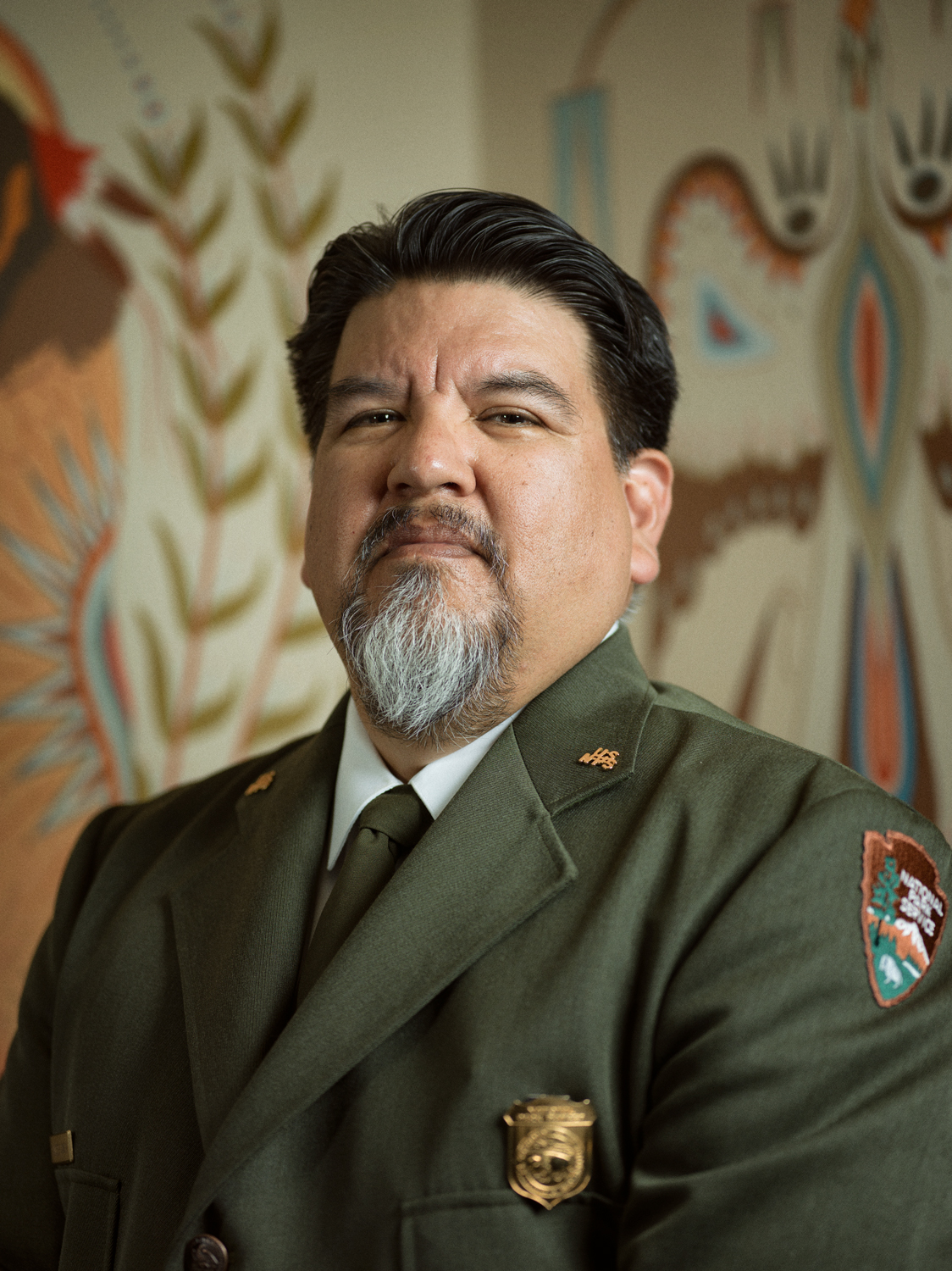
National Park Service Director Chuck Sams
Charles F. Sams III
19th National Park Service Director
Charles F. “Chuck” Sams III was ceremonially sworn in as the 19th director of the National Park Service on Dec. 16, 2021, by Interior Secretary Deb Haaland.
Sams is Cayuse and Walla Walla and is an enrolled member of the Confederated Tribes of the Umatilla Indian Reservation in Northeast Oregon, where he grew up. He also has blood ties to the Cocopah Tribe and Yankton Sioux of Fort Peck.
Sams most recently served as Oregon Governor Kate Brown’s appointee to the Pacific Northwest Power and Conservation Council (NW Council) where he held a position as a council member from March to December of 2021. Prior to joining the NW Council, he served as executive director for the Confederated Tribes of the Umatilla Indian Reservation.
For 30 years, Sams has worked in tribal and state government, and in the non-profit natural resource and conservation management field, with an emphasis on the responsibility of strong stewardship for land preservation for this and future generations.
Sams is a veteran of the U.S. Navy where he served as an intelligence specialist. He holds a Bachelor of Science in business administration from Concordia University and a Master of Legal Studies in Indigenous Peoples Law from the University of Oklahoma School of Law. He lives with his wife, Lori Lynn (Reinecke) Sams and their youngest daughter in Alexandria, VA.